Tuesday, November 17 edition · South Florida
The most advanced fishing forecast on the water.
A free account opens the app. It keeps working offshore.
Forecasts, satellite water, depth and tides. One place to plan the run, read the conditions and remember every trip.
- ----
- ----
- ----
- ----
- ----
- ----
- Today----
- Tomorrow----

The chart off Miami on the NOAA chart with the reefs, wrecks, spots and live stations. Captured October 28, 2026. Open the chartThe phone: Home on a phone at Fowey Rocks Edge, scrolled from the top. Captured October 28, 2026.
- 67 chart layers
- 131 public data feeds
- 9,518 mapped places
- 412 studies and agency reports cited
Find your next window.
Choose your water and your fish. See the best Free bet from the current forecast, then open the chart to inspect the conditions behind it.
FreeToday and tomorrow, the median of seven models, and your home spot hour by hour.
Pro, the same tripEvery spot in South Florida ranked for mahi, all seven days, with the skill-weighted score. What Pro adds
What goes into the forecast
Seven weather models and four wave models graded against NOAA buoys: 4,827,273 hourly wind forecasts in the archive, scored through August 27, 2026; receipts graded daily through November 16, 2026. Read with the latest 2 km satellite water over 9,518 mapped places.
Graded on 137,452 station-hours of NOAA readings at 8 stations in the archive, scored through August 27, 2026; receipts graded daily through November 16, 2026.
Read the full pitch
Every edition, Anglrithm runs seven weather models and four wave models for every hour of your trip, grades each against the NOAA station nearest your spot and, in Pro, gives the most weight to the model with the best record: 4,827,273 hourly wind forecasts in the archive, scored through August 27, 2026; all four wave models graded daily at three buoys; and every call graded against the buoy the next day, through November 16, 2026. Then it reads the latest 2 km satellite pass for the edges where the water turns, names the side to fish and how many days each break has held, and stacks the current and eddies, the weed lines, radar, tides, seas and the drift from your mark over 9,518 mapped places, from reefs, wrecks and ledges to moorings and ramps, inside the zones that apply. Inshore it adds the tide, the Army Corps releases, water clarity, red tide and beach bacteria. The result is one answer from Stuart to Key West and the southwest Gulf for 14 fish: the spot, the hour the window opens, whether the seas fit your boat, and the reason behind every call.
From the forecast to the call, in eight steps.
67 chart layers, each with its source and age.
67 chart layers on four base maps, from 131 public data feeds and 49 agencies and providers. 22,304,082 forecast values graded against buoy readings in the archive, scored through August 27, 2026; receipts graded daily through November 16, 2026. 9,518 mapped places. 412 studies and agency reports cited. 14 fish.
Water 30
- Temperature breaks
- Colour breaks
- Coastline
- Inland water
- Water temperature
- Water temperature vs normal
- Water colour
- Coral heat stress
- Water temperature at depth
- Mixed layer depth
- Current
- Measured current (HF radar)
- Tidal currents
- Forecast current
- Water Match
- A Spot areas
- Sargassum (weed)
- Eddies
- Red tide samples
- Fish kill reports
- Beach bacteria
- Water quality sensors
- Army Corps structures
- Science marks
- Water clarity
- Depth shading
- Survey relief
- Depth contours
- Shallower than your draft
- Inlets and beach fill
Structure 16
Rules 5
Weather 13
Right now on the water.
When and where to go next, answered four ways.
1. When to go
Learn more about when to go2. Where to go
Learn more about where to go3. Plan the trip
Learn more about plan the trip4. Your log, with context
Learn more about your log, with context
Every call, graded against the buoy.
Every receiptOffshore and inshore, on one chart.
Offshore.
The temperature and colour breaks, the current and eddies, the weed lines and the drift from your mark, over 2,153 wrecks and reefs. Seven weather models and four wave models for the run out, all four wave models graded daily at three buoys.

Inshore.
The tide at 78 stations, the Army Corps releases and the runoff on an outgoing tide, water clarity, red tide and beach bacteria. The manatee and no-take zones, and light wind, which helps sight fishing for tarpon, bonefish, permit and redfish with the sun up.

It says no when the answer is no.
Most days are not worth the fuel. When none is, it says so, and the free Morning Call tells you the day before a good one.
Get the Morning Call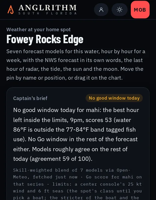
Before you ask.
What does it cost?
Free: today's and tomorrow's edition for every region with every reason shown, your home spot scored hour by hour, today's score at any spot, the NOAA chart, radar, the latest water temperature and the best edge, a catch log with no cap (exports leave the positions out) and the weekly Sick Day email. Pro is $5.99 a month or $68.99 a year: seven days, every spot and mark, hour by hour and tomorrow at every spot, chlorophyll and colour breaks, weed detections, eddies and the altimetry current, Sick Day email and push every day, the full edition archive, every temperature break with GPX, your marks and catches exported with their positions. Warnings, the float plan, man overboard, the accuracy scoreboard, the structure cards and water health are free on every plan.
Do I need to make an account?
Yes, a free one. The landing page shows today's best bet without one; the app needs an account, which opens it and carries your spots and your Sick Day alerts. Google or email; nothing is sold or shared. A float plan you share opens for anyone, no account needed.
How does the free trial work?
15 days of Pro on either plan, once per email. Your card is taken at the start; we email you 3 days before the end; you are charged on day 15 unless you cancel. Cancel from Account in two clicks.
What happens when I cancel?
Pro ends that day and we refund the unused full days of the period, prorated by the day; your free account continues with your log, marks and trips. A trial ends at once and is never charged.